| Where? | Description | What? |
|---|---|---|
| Link (92 MiB) | 1985-01-07 time series for this field. | #counterpart ivo://org.gavo.dc/~?flare_survey/data/plates/ESO040_004362.fits |
| Link (92 MiB) | 1985-01-10 time series for this field. | #counterpart ivo://org.gavo.dc/~?flare_survey/data/plates/ESO040_004362.fits |
| Link (92 MiB) | 1985-01-11 time series for this field. | #counterpart ivo://org.gavo.dc/~?flare_survey/data/plates/ESO040_004362.fits |
| Link (92 MiB) | 1985-01-13 time series for this field. | #counterpart ivo://org.gavo.dc/~?flare_survey/data/plates/ESO040_004362.fits |
| Link (92 MiB) | 1985-01-14 time series for this field. | #counterpart ivo://org.gavo.dc/~?flare_survey/data/plates/ESO040_004362.fits |
| Link (88 MiB) | 1985-01-14 time series for this field. | #counterpart ivo://org.gavo.dc/~?flare_survey/data/plates/ESO040_004362.fits |
| Link (92 MiB) | 1985-01-15 time series for this field. | #counterpart ivo://org.gavo.dc/~?flare_survey/data/plates/ESO040_004362.fits |
| Link (92 MiB) | 1985-01-15 time series for this field. | #counterpart ivo://org.gavo.dc/~?flare_survey/data/plates/ESO040_004362.fits |
| Link (92 MiB) | 1985-01-16 time series for this field. | #counterpart ivo://org.gavo.dc/~?flare_survey/data/plates/ESO040_004362.fits |
| Link (92 MiB) | 1985-01-16 time series for this field. | #counterpart ivo://org.gavo.dc/~?flare_survey/data/plates/ESO040_004362.fits |
| Link (92 MiB) | 1985-01-17 time series for this field. | #counterpart ivo://org.gavo.dc/~?flare_survey/data/plates/ESO040_004362.fits |
| Link (92 MiB) | 1985-01-18 time series for this field. | #counterpart ivo://org.gavo.dc/~?flare_survey/data/plates/ESO040_004362.fits |
| Link (92 MiB) | 1985-01-21 time series for this field. | #counterpart ivo://org.gavo.dc/~?flare_survey/data/plates/ESO040_004362.fits |
| Link (92 MiB) | 1985-01-22 time series for this field. | #counterpart ivo://org.gavo.dc/~?flare_survey/data/plates/ESO040_004362.fits |
| Link (92 MiB) | 1985-01-22 time series for this field. | #counterpart ivo://org.gavo.dc/~?flare_survey/data/plates/ESO040_004362.fits |
| Link (92 MiB) | 1985-01-23 time series for this field. | #counterpart ivo://org.gavo.dc/~?flare_survey/data/plates/ESO040_004362.fits |
| Link (92 MiB) | 1985-01-24 time series for this field. | #counterpart ivo://org.gavo.dc/~?flare_survey/data/plates/ESO040_004362.fits |
| Link (92 MiB) | 1985-01-24 time series for this field. | #counterpart ivo://org.gavo.dc/~?flare_survey/data/plates/ESO040_004362.fits |
| Link (92 MiB) | 1985-01-25 time series for this field. | #counterpart ivo://org.gavo.dc/~?flare_survey/data/plates/ESO040_004362.fits |
| Link (92 MiB) | 1985-01-26 time series for this field. | #counterpart ivo://org.gavo.dc/~?flare_survey/data/plates/ESO040_004362.fits |
| Link (92 MiB) | 1985-01-26 time series for this field. | #counterpart ivo://org.gavo.dc/~?flare_survey/data/plates/ESO040_004362.fits |
| Link (92 MiB) | 1985-01-27 time series for this field. | #counterpart ivo://org.gavo.dc/~?flare_survey/data/plates/ESO040_004362.fits |
| Link (92 MiB) | 1989-01-01 time series for this field. | #counterpart ivo://org.gavo.dc/~?flare_survey/data/plates/ESO040_004362.fits |
| Link (92 MiB) | 1989-01-01 time series for this field. | #counterpart ivo://org.gavo.dc/~?flare_survey/data/plates/ESO040_004362.fits |
| Link (92 MiB) | 1989-01-02 time series for this field. | #counterpart ivo://org.gavo.dc/~?flare_survey/data/plates/ESO040_004362.fits |
| Link (92 MiB) | 1989-01-02 time series for this field. | #counterpart ivo://org.gavo.dc/~?flare_survey/data/plates/ESO040_004362.fits |
| Link (92 MiB) | 1989-01-03 time series for this field. | #counterpart ivo://org.gavo.dc/~?flare_survey/data/plates/ESO040_004362.fits |
| Link (92 MiB) | 1989-01-03 time series for this field. | #counterpart ivo://org.gavo.dc/~?flare_survey/data/plates/ESO040_004362.fits |
| Link (92 MiB) | 1989-01-03 time series for this field. | #counterpart ivo://org.gavo.dc/~?flare_survey/data/plates/ESO040_004362.fits |
| Link (92 MiB) | 1989-01-03 time series for this field. | #counterpart ivo://org.gavo.dc/~?flare_survey/data/plates/ESO040_004362.fits |
| Link (92 MiB) | 1989-01-04 time series for this field. | #counterpart ivo://org.gavo.dc/~?flare_survey/data/plates/ESO040_004362.fits |
| Link (92 MiB) | 1989-01-04 time series for this field. | #counterpart ivo://org.gavo.dc/~?flare_survey/data/plates/ESO040_004362.fits |
| Link (92 MiB) | 1989-01-05 time series for this field. | #counterpart ivo://org.gavo.dc/~?flare_survey/data/plates/ESO040_004362.fits |
| Link (92 MiB) | 1989-01-05 time series for this field. | #counterpart ivo://org.gavo.dc/~?flare_survey/data/plates/ESO040_004362.fits |
| Link (92 MiB) | 1989-01-05 time series for this field. | #counterpart ivo://org.gavo.dc/~?flare_survey/data/plates/ESO040_004362.fits |
| Link (92 MiB) | 1989-01-06 time series for this field. | #counterpart ivo://org.gavo.dc/~?flare_survey/data/plates/ESO040_004362.fits |
| Link (92 MiB) | 1989-01-06 time series for this field. | #counterpart ivo://org.gavo.dc/~?flare_survey/data/plates/ESO040_004362.fits |
| Link (92 MiB) | 1989-01-06 time series for this field. | #counterpart ivo://org.gavo.dc/~?flare_survey/data/plates/ESO040_004362.fits |
| Link (92 MiB) | 1989-01-06 time series for this field. | #counterpart ivo://org.gavo.dc/~?flare_survey/data/plates/ESO040_004362.fits |
| Link (92 MiB) | 1989-01-07 time series for this field. | #counterpart ivo://org.gavo.dc/~?flare_survey/data/plates/ESO040_004362.fits |
| Link (92 MiB) | 1989-01-08 time series for this field. | #counterpart ivo://org.gavo.dc/~?flare_survey/data/plates/ESO040_004362.fits |
| Link (92 MiB) | 1989-01-08 time series for this field. | #counterpart ivo://org.gavo.dc/~?flare_survey/data/plates/ESO040_004362.fits |
| Link (92 MiB) | 1989-01-10 time series for this field. | #counterpart ivo://org.gavo.dc/~?flare_survey/data/plates/ESO040_004362.fits |
| Link (92 MiB) | 1989-01-11 time series for this field. | #counterpart ivo://org.gavo.dc/~?flare_survey/data/plates/ESO040_004362.fits |
| Link (92 MiB) | 1989-01-12 time series for this field. | #counterpart ivo://org.gavo.dc/~?flare_survey/data/plates/ESO040_004362.fits |
| Link (92 MiB) | 1990-01-18 time series for this field. | #counterpart ivo://org.gavo.dc/~?flare_survey/data/plates/ESO040_004362.fits |
| Link (92 MiB) | 1990-01-19 time series for this field. | #counterpart ivo://org.gavo.dc/~?flare_survey/data/plates/ESO040_004362.fits |
| Link (92 MiB) | 1990-01-20 time series for this field. | #counterpart ivo://org.gavo.dc/~?flare_survey/data/plates/ESO040_004362.fits |
| Link (92 MiB) | 1990-01-20 time series for this field. | #counterpart ivo://org.gavo.dc/~?flare_survey/data/plates/ESO040_004362.fits |
| Link (92 MiB) | 1990-01-21 time series for this field. | #counterpart ivo://org.gavo.dc/~?flare_survey/data/plates/ESO040_004362.fits |
| Link (92 MiB) | 1990-01-22 time series for this field. | #counterpart ivo://org.gavo.dc/~?flare_survey/data/plates/ESO040_004362.fits |
| Link (92 MiB) | 1990-01-24 time series for this field. | #counterpart ivo://org.gavo.dc/~?flare_survey/data/plates/ESO040_004362.fits |
| Link (92 MiB) | 1990-01-24 time series for this field. | #counterpart ivo://org.gavo.dc/~?flare_survey/data/plates/ESO040_004362.fits |
| Link (92 MiB) | 1990-01-29 time series for this field. | #counterpart ivo://org.gavo.dc/~?flare_survey/data/plates/ESO040_004362.fits |
| Link (92 MiB) | 1990-01-30 time series for this field. | #counterpart ivo://org.gavo.dc/~?flare_survey/data/plates/ESO040_004362.fits |
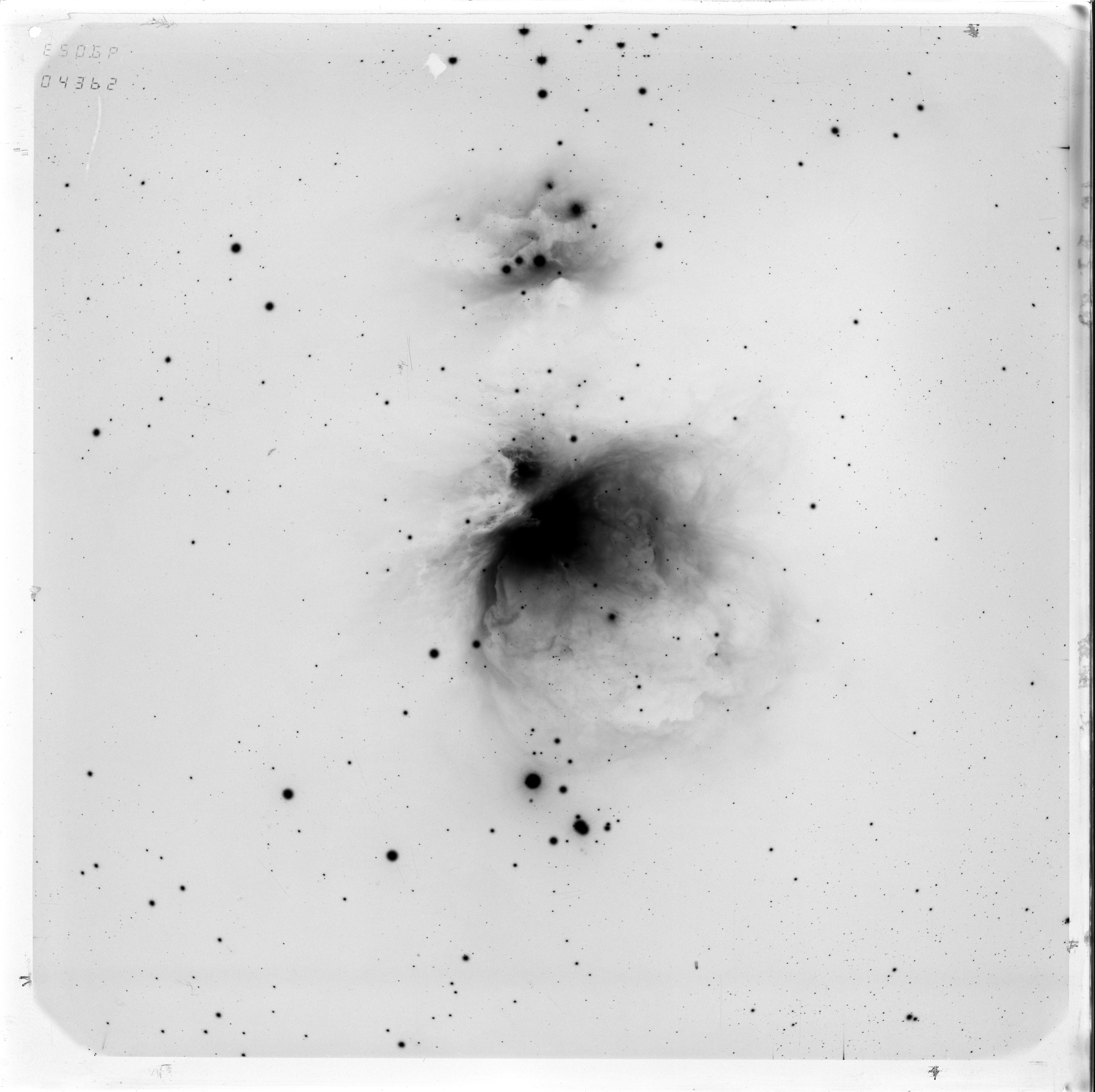
| Link (6 MiB) | Mid-resolution plate photo. | #preview-image ivo://org.gavo.dc/~?flare_survey/data/plates/ESO040_004362.fits |
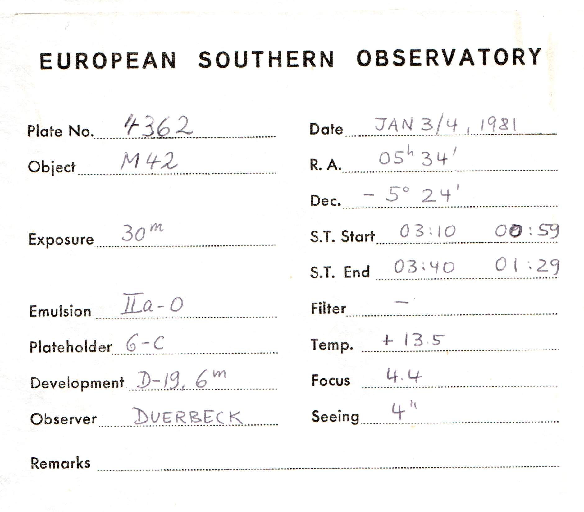
| Link (172 kiB) | Photo of the plate envelope. | #documentation ivo://org.gavo.dc/~?flare_survey/data/plates/ESO040_004362.fits |
| (Form) | This service produces datalinks for the reference images of the M?nster flare survey plates. Most importantly, this links to the related time series exposures, but there are also links to plates in other epochs and to envelopes and plate photos. | #proc ivo://org.gavo.dc/~?flare_survey/data/plates/ESO040_004362.fits |
| Link (92 MiB) | The full dataset. | #this ivo://org.gavo.dc/~?flare_survey/data/plates/ESO040_004362.fits |
| Link | A preview for the dataset. | #preview ivo://org.gavo.dc/~?flare_survey/data/plates/ESO040_004362.fits |